“Palaeodrainage Evolution of the Large Rivers of East Asia, and Himalayan-Tibet Tectonics” is published in Earth-Science Reviews (Volume 192, May 2019, Pages 601-630). It is a collaborative achievement of Prof. MEI Lianfu’s team from the School of Earth Resources, Prof. Yani Najman from Lancaster University, and other researchers. The first author is doctoral student ZHANG Peng; Prof. MEI Lianfu and Prof. Yani Najman are the corresponding authors.
Understanding the tectonics that gave rise to the formation of Tibet is critical to our understanding of crustal deformation processes. The unusual geomorphology of the drainage basins of East Asia's major rivers has been proposed to be the result of either (1) distortion and attenuation of antecedent drainages as India indents into Asia, which can therefore be used as passive strain markers of horizontal shear, or (2) due to fragmentation by river captures and flow reversals of an originally continental-scale drainage, in which the major East Asian rivers once flowed into the palaeo-Red River. If the latter hypothesis is correct, then it has been proposed that dating the drainage fragmentation constrains the timing of uplift of Tibet.
A number of sedimentary provenance studies have been undertaken in order to determine whether the palaeo-Red River was once a river of continental proportions into which the upper reaches of the Yangtze, Salween, Mekong, Irrawaddy, and Yarlung drained.
We have assessed the evidence that the Yarlung originally flowed into the palaeo-Red river, and then sequentially into the Irrawaddy and Brahmaputra, connecting to the latter first via the Lohit and then the Siang. For this river system, we have integrated our new data from the Paleogene-Recent Irrawaddy drainage basin (detrital zircon U-Pb with Hf and fission track, rutile U-Pb, mica Ar-Ar, bulk rock Sr-Nd, and petrography) with previously published data, to produce a palaeodrainage model that is consistent with all datasets. In our model, the Yarlung never flowed into the Irrawaddy drainage: during the Paleogene, the Yarlung suture zone was an internally drained basin, and from Neogene times onwards the Yarlung drained into the Brahmaputra in the Bengal Basin. The Central Myanmar Basin, through which the Irrawaddy River flows today, received predominantly locally-derived detritus until the Middle Eocene, the Irrawaddy initiated as a through-going river draining the Mogok Metamorphic Belt and Bomi-Chayu granites to the north sometime in the Late Eocene to Early Oligocene, and the river was dominated by a stable MMB-dominated drainage throughout the Neogene to present day. Existing evidence does not support any connection between the Yarlung and the Red River in the past, but there is a paucity of suitable palaeo-Red River deposits with which to make a robust comparison. We argue that this limitation also precludes a robust assessment of a palaeo-connection between the Yangtze/Salween/Mekong and the Red River; it is difficult to unequivocally interpret the recorded provenance changes as the result of specific drainage reorganisations. We highlight the palaeo-Red River deposits of the Hanoi Basin as a potential location for future research focus in view of the near-complete Cenozoic record of palaeo-Red River deposits at this location.
A majority of previous studies consider that if a major continental-scale drainage ever existed at all, it fragmented early in the Cenozoic. Such a viewpoint would agree with the growing body of evidence from palaeoaltitude studies that large parts of SE Tibet were uplifted by this period. This then leads towards the intriguing question as to the mechanisms which caused the major period of river incision in the Miocene in this region.
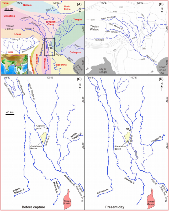
Fig. 1. (A) Modern day drainage of East Asia showing the unusually closely-spaced geometry of the Yangtze, Salween and Mekong in their middle reaches, superimposed on the tectonic units of the region. Contours are in metres. Figure modified from Clark et al. (2004) with tectonic unit boundaries compiled from a number of sources, including Zhang et al. (1985), Metcalfe (1996), and Pan et al. (2012). Box shows the location of Fig. 1C. (B) Proposed reconstructed drainage, from Clark et al. (2004), with the upper reaches of the Yangtze, Salween, Mekong, Irrawaddy headwaters and Yarlung flowing into the palaeo-Red River, forming a continental-scale drainage network. (C-D) Detail of the proposed river capture and drainage reversal at the “First Bend” in the Yangtze. FB = First Bend; SHYB = Song Hong-Yinggehai Basin.
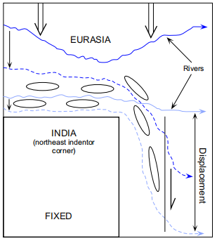
Fig. 2. Schematic representation of the hypothesis of Hallet and Molnar (2001), fixed relative to India, showing that for a parcel of crust just north of the Eastern Himalayan syntaxis, the dominant strains will first be largely compressive, in a direction radial to the syntaxis and then display roughly north-south right-lateral shear as it moves south of the syntaxis. Initial and final positions of the rivers are shown as solid and dotted lines, respectively. Ellipses represent the magnitude and direction of the crustal strains.
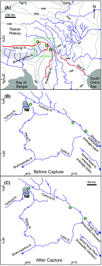
Fig. 3. Proposed reconstruction of the Yarlung-Irrawaddy-Red river palaeodrainage (after Clark et al., 2004): (A) Overview of the suggested successive captures and reversals (circles labelled 1–3) of the Yarlung River from the palaeo-Red River by the Irrawaddy River, and most recently by the Brahmaputra River via the Lohit and then Siang Rivers, in the area of the Eastern Himalayan syntaxis. Red dashed line indicates the original path of the Yarlung River into the Red River; red dotted line indicates the path of the Yarlung River into the Irrawaddy drainage. Green box in panel A shows location of figures in panel B and C. (B) and (C) gives detail of the final major capture: prior to capture (B), the palaeo-Yarlung River flowed into the Irrawaddy River through the Parlung (shaded area represents the topographic expression of the Namche Barwa massif (NB) of the Eastern Himalayan syntaxis); (C) the Yarlung River flows into the Brahmaputra, first via the Lohit and then via the Siang.
Link: https://doi.org/10.1016/j.earscirev.2019.02.003