Accurate understanding the distribution of drought and flood pattern is of great significance to national economy construction and national security. Modern climate research shows that there exist two different rainfall patterns in the monsoonal regions along eastern China, the dipole pattern with southern flooding and Northern drought, and the tripole pattern with out-of-phase relationship between rainfall over the Yangtze river basin and north China and south China. However, modern meteorological observation only covers in recent decades, which unable to capture the climate system characteristics on longer time scales. As a result, it is still unclear about the causes of these two different rainfall modes.
In the November 2, 2018, Prof. Xie Shucheng’s group from China University of and Colleagues published the paper entitled “East Asian hydroclimate modulated by the position of the westerlies during Termination I” on Science (Vol. 362, Issue 6414, pp. 580-583). Dr. Hongbin Zhang, assistant professor in the State Key Laboratory of Biogeology and Environmental Geology was the first author.
Using a new multiproxy record of hydroclimate from East Asian speleothems covering the last deglaciation, their research indicated a wetter central eastern China during North Atlantic cooling episodes, despite the traditional oxygen isotopic record suggesting a weaker monsoon. Through a North Atlantic freshwater ‘hosing’ experiment utilizing a fully coupled Community Earth System Model, they found that the model simulations were in agreement with proxy results, showing an out-of-phase relationship in rainfall, with wetter conditions in central eastern China matched by drier conditions in northeastern China.
The dynamics mechanism about these large-scale changes in the Asian monsoon, and more ‘local-scale’ precipitation changes was interpreted as a change to the seasonality of East Asian rainfall, namely a lagged termination of the East Asian Meiyu rainfall stage and shortened Midsummer stage. Model simulation also revealed a southward-shifted westerlies over Asia, induced by increased meridional temperature gradients, connected the North Atlantic stadial events to changes over East Asia, ultimately causing the shift in East Asian rainfall seasonality.
Following this publication, one science perspective paper was published on Science journal in the same issue, “Shifting summer rains” (Vol. 362, Issue 6414, pp. 518-520) by David McGee from Massachusetts Institute of Technology, which make a great evaluation to this work, as summarized in two sentences:
“This finding of antiphased regional rainfall patterns in China, and of the key role of the jet stream's position in producing them, makes several important contributions to our understanding of the past and future of the EASM.”
“The results of Zhang et al. also demonstrate the importance of current and future warming of the Northern Hemisphere's high latitudes for regional rainfall patterns in China”
Article link:
Zhang, H. et al. East Asian hydroclimate modulated by the position of the westerlies during Termination I. Science 362, 580-583, doi:10.1126/science.aat9393 (2018).
https://science.sciencemag.org/content/362/6414/580
McGee, D. Shifting summer rains. Science 362, 518-520, doi:10.1126/science.aav5280 (2018).
https://science.sciencemag.org/content/362/6414/518
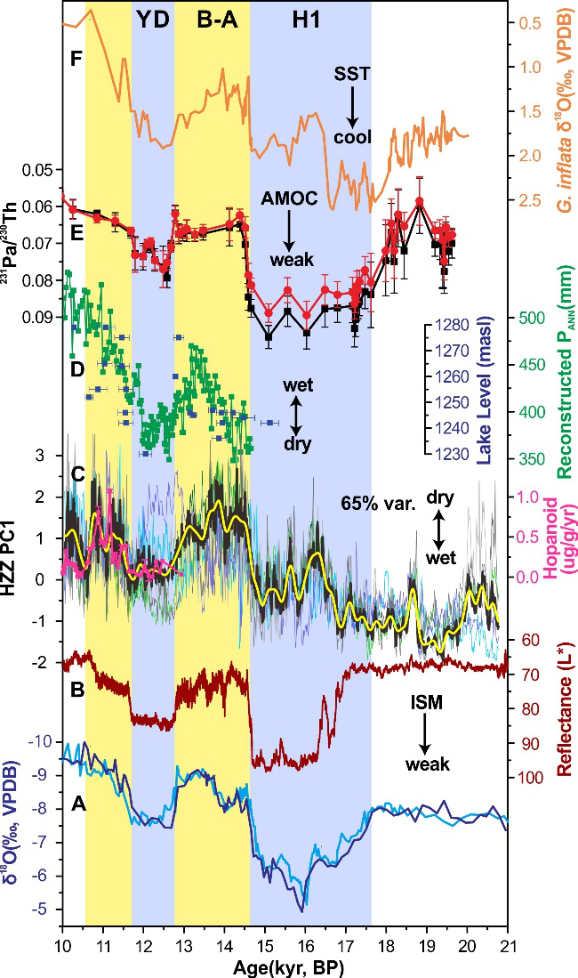
Fig. 2. Central China hydroclimate and high northern latitude teleconnections during the last deglaciation. (A) δ18O records of HZZ11 and HZZ27 (14). (B) Arabian Sea sediment total reflectance (L*), a proxy for Indian summer monsoon strength (18). (C) Leading PC (HZZ PC1; black curve) of HZZ11 and HZZ27 Mg/Ca, Sr/Ca, and Ba/Ca records and hopanoid flux (pink curve), a proxy for water-table depth from nearby Dajiuhu peatland (23). Overlapped thin lines show the standardized Sr/Ca, Mg/Ca, and Ba/Ca records. Yellow line shows HZZ PC1 smoothed with a 100 yr loess filter. (D) Reconstructed annual precipitation (green) and lake level (blue) in North China from Gonghai Lake (24) and Dali Lake (25) respectively. (E-F) North Atlantic sediment core GGC5 231Pa/230Th (proxy for AMOC) and planktonic foraminifera δ18O (proxy for SST) (22).
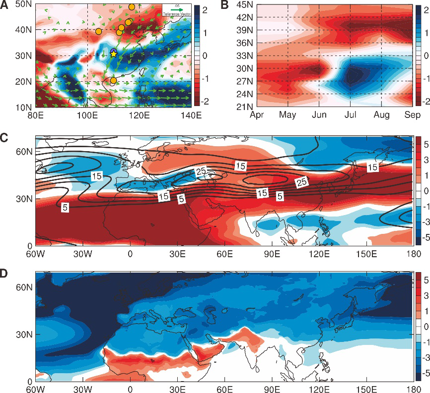
Fig. 3. CESM 1.0.5 simulated precipitation and Asian westerlies anomalies between 1Sv hosing experiment and control simulation. (A) July-August rainfall anomalies in East Asia (shading; unit: mm/day) superimposed with moisture flux anomalies at 850mb (vectors; unit: kg/kg m/s). The yellow star and blue circle show sites [Haozhu cave (star, this study) and Dajiuhu peatland (circle, 23)] indicating wet conditions during H1 and/or YD, and orange circles show sites indicating dry conditions during H1 and/or YD (see Fig. S1 for list of sites). (B) Hovmöller diagram of rainfall anomalies zonally averaged between 110°-120°E (unit: mm/day). This shows the increase in rainfall over central eastern China in July-Aug and decreased rainfall to the north. (C) July-August zonal wind at 200mb from the control run (contour; interval 5m/s) and anomalies from the 1Sv ‘hosing’ run (shading), showing the equatorward displacement of the jet in the ‘hosing’ simulation. (D) 2-meter July-Aug air temperature anomalies (unit: K). 100 years climatology of the control run and 80 years climatology of the ‘hosing’ run after spin-up were used to generate the anomalies.